Publishing date: 08/09/2025
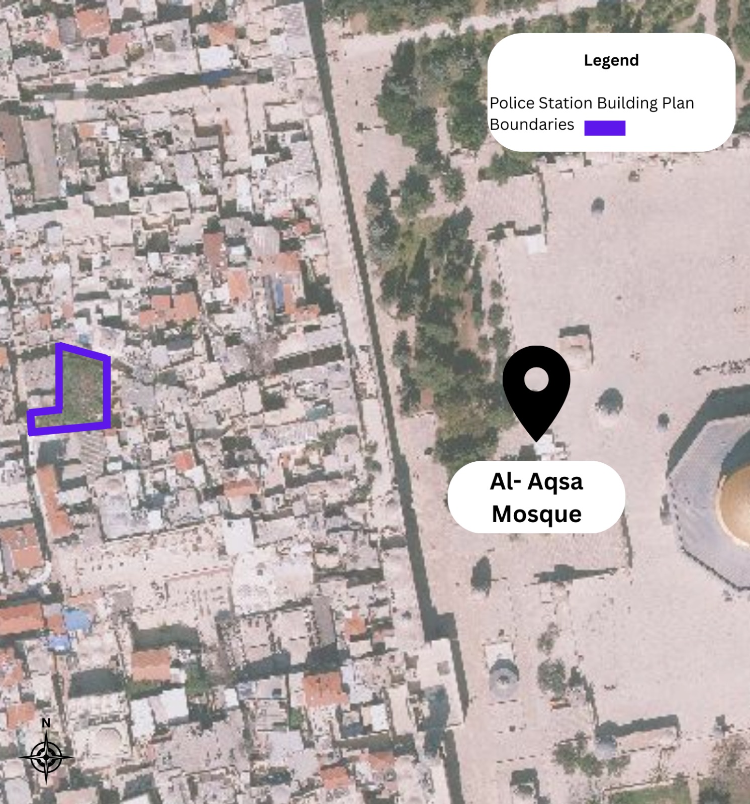
Map showing the location of the plan
Initiator
The Israeli Government Ministry of Finance/Housing, via the Police Representative of housing – Itzik Levy.
Implementing Body
The project is managed through the Security Facilities Committee (ולמ״ב) under Israeli governmental authority.
Location
4 Bab al-Hadid Street, Old City – Jerusalem.
The site adjoins what is known as “Beit Hanina,” confiscated by Israeli authorities and currently used as an “Israeli community police center”.
It lies between Bab al-Hadid Street and al-Wad Street, in the heart of a densely populated residential area. It is surrounded above by Palestinian homes and below by commercial shops, including a bakery threatened with demolition.
Project Description
Construction of a new police building on a plot of land measuring 440 m².
• Proposed construction volume: 230% of the land area.
• Number of floors: three.
• The site is zoned under Master Plan No. “Am/9” (עמ/9) as a private residential area. It was privately owned by the Al-Mu’aqqat, Al-Tarhri, and Abu Mayyala families, who had built a small one-room structure on part of the land.
• The land constitutes the only remaining open space in the neighborhood and is considered a vital green lung in a heavily built-up area.
Status
• In the 1960s, a military order was issued to demolish the then-existing building, leaving the land subject to successive legal proceedings.
• In subsequent court rulings (including on 15/06/2008), the Jerusalem Magistrate’s Court affirmed that confiscation orders do not annul ownership rights, and the state may not alter the land’s status or transfer it for lease or ownership to any party.
• On 8 October 2024, an application for a permit to build the “security” complex was submitted, with a public notice posted near the site allowing only 15 days for objections.
• In March 2025, responses to the objections were issued, and a hearing was scheduled for 17 July 2025.
• On 17 July 2025, the hearing took place, with objectors and police representatives presenting their arguments. As of August 2025, no response to the objections has been issued.
Approving Authority
The Security Facilities Committee (ולמ״ב), chaired by Shira Talmi – Head of the Jerusalem District Planning and Building Committee.
Objections
In November 2024, six objections were submitted:
• Five objections by attorneys Wasim Ghnaim and Muhannad Jabara on behalf of the landowners and local residents.
• The sixth objection by the Arab Center for Alternative Planning (ACAP), in cooperation with the Norwegian Refugee Council (NRC), which later presented its objection before the competent planning committee.
Key Grounds of ACAP’s Objection
• Violation of due process: Use of a shortened permit pathway, inadequate objection period (only 15 days), with no genuine justification for the project’s “security” or “confidential” character.
• Negative environmental and urban impacts: Destruction of the neighborhood’s only open space, reduced ventilation and natural light, and increased local heat.
• Structural risks to neighboring buildings: Direct threats to historic structures due to excavation, vibrations, and changes to groundwater levels, with no preventive engineering studies.
• Social and community impacts: Undermining community safety, lowering property values, and causing population outmigration due to direct, discriminatory friction against residents.
• Infrastructure strain: Added pressure on already overburdened networks—electricity, water, sewage, and narrow congested roads.
• Lack of alternatives and resident participation: No alternative sites were examined, and residents were not included in decision-making, in clear violation of participatory planning principles.
Site Photos
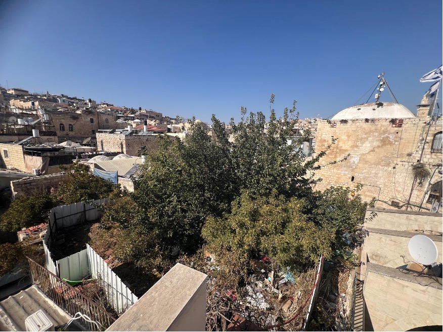
The planned site is located where the tree in the photo above and the surrounding open space stand.
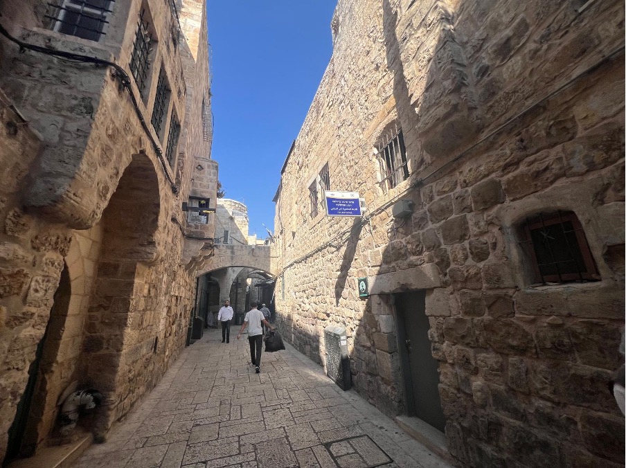
The entrance to the planned site is at the end of this passageway on the right-hand side. The current community police center (shown in the photo with a blue sign on the right wall) forms the street frontage, while the new plan is located directly behind this building.